Take Our Content to Go
Mosaic ATM’s Fleet Logistics Optimization Engine (FLOE) addresses the current challenges of fleet and flight operations but also lays the groundwork for the future of uncrewed aviation.
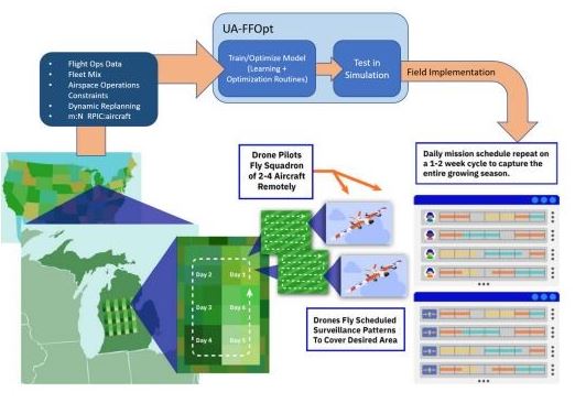
Aerial missions are becoming indispensable across industries, and optimizing operations for uncrewed aircraft and their supporting ground crews is critical. Mosaic ATM’s Uncrewed Aircraft Fleet & Flight Operations Optimization (UA-FFOpt) was designed to investigate this challenge by creating a proof-of-concept system aimed at optimizing large-region missions in terms of both aircraft flight time and ground crew costs.
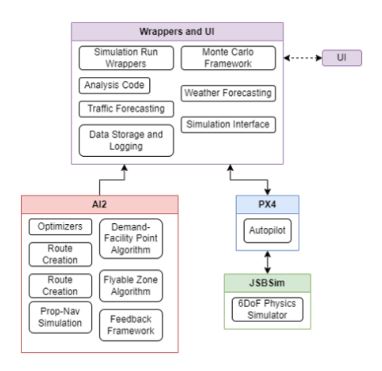
Its successor, the Fleet Logistics Optimization Engine (FLOE), builds on this foundation by incorporating real-time data, advanced simulation tools, commonly used autopilot interfaces, and refined feedback systems while expanding the optimization processes into other use cases beyond what were originally investigated. In particular, the FLOE software focuses on both 1:n and m:n command and control operations. FLOE brings a powerful ground control, simulation test suite, mission planner, and layered backend optimization methodology to create a single industry-disrupting tool.
Introduction
The growing demand for uncrewed aerial systems in agriculture, logistics, environmental monitoring, and disaster response has highlighted the inefficiencies inherent in traditional mission planning. Existing approaches often struggle with integrating dynamic environmental factors like weather, traffic, and airspace restrictions while optimizing large fleet deployment and complex routing over a variety of region types.
The UA-FFOpt solution emerged to combat these challenges by applying advanced algorithms and modular optimization to streamline mission operations. Its evolution into FLOE reflects a commitment to greater scalability, adaptability, and integration with real-world data streams. Originally, UA-FFOpt was conceived to address very specific mission challenges encountered when attempting to survey large swaths of farmland. However, it quickly became apparent that the devised solution applied to a number of similar situations across industries – ideal deployment locations, efficient routing, planning around restricted airspace, and planning around dynamic weather and traffic are all desired to help automate highly efficient mission planning.
Most importantly, UA-FFOpt introduced a novel method of minimizing ground crew deployment costs and aircraft flight time using a modular layered optimization system. These optimizers can be swapped out for other optimizers as the mission requires and improved using a logged data feedback system for automated improvement and refinement. This highly scalable architecture laid the groundwork for the FLOE software—a system capable of not only managing current challenges but also adapting dynamically to future demands.
A Comprehensive Approach to Fleet Optimization
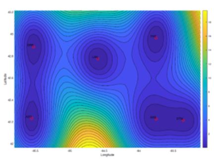
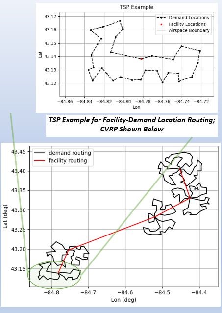
UA-FFOpt is built around the core idea of optimizing both aircraft and ground crew operations through advanced algorithms. At its heart, the system seeks to identify the most optimum survey locations and associated takeoff/landing sites (i.e. deployment locations). The optimization process evaluates these locations and connections to minimize costs and flight times while maximizing the surveyed area.
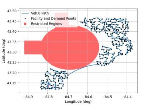
A novel two-stage optimization process drives UA-FFOpt. The first stage determines the most efficient arrangement of deployment locations (i.e. minimizing drive time and ground crew costs while maximizing the reachable surveyable area). In contrast, the second stage focuses on efficiently routing aircraft between the survey locations from each associated deployment location while maintaining constraints such as battery limitations, restricted airspace, radio range, and line-of-sight requirements.
The original system (UA-FFOpt) leveraged algorithms such as the Facility Location Planning (FLP) algorithm, the Traveling Salesperson Problem (TSP), and the Capacitated Vehicle Routing Problem (CVRP) to solve these challenges. However, as the system was designed from the start with a highly modular object-oriented architecture in mind, these are easily swapped for other methods such as Genetic Algorithms which are Being implemented in the current FLOE software package among others.
Another key feature of the system aimed specifically at agricultural use cases is the crop-type predictor. This uses pixel-level GeoTIFF data and Naïve Bayes models to forecast the types of crops present in surveyed fields at the beginning of the growing season when current crop data is not yet readily available. This prediction is critical for crop survey mission planning when specific crop types are of interest and wasted flight time needs to be minimized. This is especially important as mission regions scale up to cover counties and even states with hundreds or thousands of potential fields to survey.
To ensure these optimizations are actionable, UA-FFOpt included a low-latency, low-fidelity simulation framework that evaluates deployment strategies, accounts for real-world features like terrain and airspace restrictions, and integrates feedback from previous missions. This feedback loop continually refines the system’s predictions and optimizations, making it more effective with each iteration. FLOE now incorporates in a medium-speed high-fidelity simulation that can seamlessly switch between simulation and real-world control for PX4 autopilots thanks to the integration of tactical autopilot software-in-the-loop and communication protocol.
Real-Time Weather and Traffic Modeling
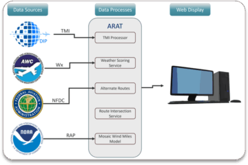
In FLOE, real-time environmental data is a critical input for routing and decision-making. Advanced AI techniques are being investigated to be used to process and integrate this data:
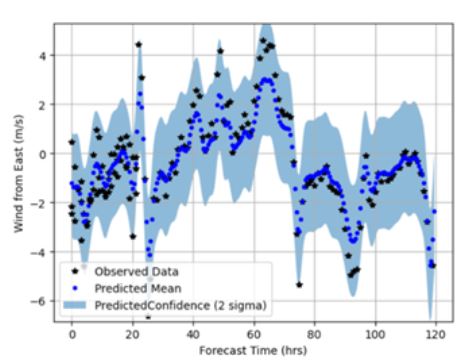
- Deep Gaussian Process (DGP) Modeling: This probabilistic approach forecasts weather conditions, including wind patterns, with quantified uncertainty. A DGP or simple Gaussian Process (GP) enables the system to anticipate environmental challenges, reducing mission interruptions caused by poor weather. This serves two purposes. First, the certainty of the weather predictions (specifically wind) can be quantified for a given area based both on prior logs and proximity to current weather stations. Secondly, this process can be used to update large-scale weather maps with additional ground-based weather measurements obtained by the ground crews or even with instrumentation or back-calculation methods coupled with the UAS.
- Custom Deep Neural Networks (DNNs): These models are trained on historical and real-time weather data to further refine predictions, especially in regions where data is sparse.
Feedback and Refinement Mechanisms
A critical innovation in UA-FFOpt and FLOE is the continuous improvement of routing and optimization algorithms through a feedback loop.
This mechanism incorporates:
- Monte Carlo Simulations: These simulations evaluate various environmental scenarios, such as changes in weather or restricted airspace. Insights from these tests are used to refine cost parameters in the Facility Location Planning (FLP) optimizer.
- Autopilot SITL: The PX4 autopilot is used as software-in-the-loop with JSBSim to create a high-fidelity simulation used for testing proposed routes and developing new methodologies.
- Regression Models: Initially implemented with linear regression, these models estimate travel times and distances between waypoints as logged kinematic and environment data is accumulated. FLOE’s development includes transitioning to more advanced ML models that account for complex, multi-variable interactions.
Advancements in FLOE
FLOE takes the foundational capabilities of UA-FFOpt to the next level by integrating real-time data streams and incorporating more advanced simulation and feedback mechanisms. Weather and traffic data, both highly variable and critical to mission success, are now being seamlessly integrated into the optimization process. For example, wind predictions derived from Deep Gaussian Process (DGP) modeling enable FLOE to anticipate conditions that might compromise image quality or increase flight times, reducing the need for repeated operations.
The feedback system in FLOE is another significant advancement. Using historical data refines the system’s understanding of waypoint-to-waypoint travel times and distances. Monte Carlo simulations further enhance this process by testing the system under varied environmental conditions, ensuring robust performance across scenarios.
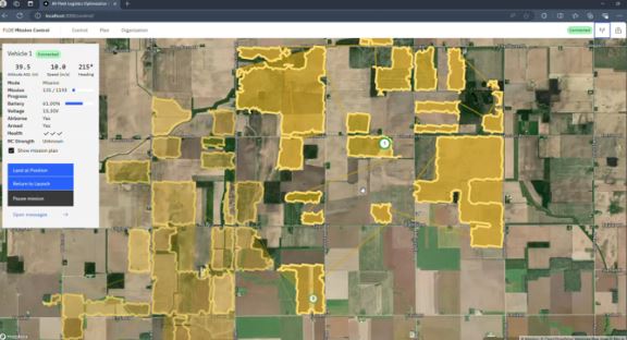
A high-fidelity simulation environment now underpins FLOE’s capabilities. Unlike the simpler simulations in UA-FFOpt, FLOE integrates PX4 autopilot software to accurately emulate real-world flight dynamics, including finite battery life and obstacle avoidance. This simulation environment also serves as the foundation for a user interface (UI) that allows operators to input mission-specific parameters, run simulations, and monitor real-time data during missions.
As FLOE continues to evolve, the integration of cutting-edge AI and ML techniques will remain a priority. Future advancements include:
- Transformer Models: To enhance crop-type prediction and route planning, transformers will process large datasets more effectively than current models.
- Deep Neural Networks: Improvements to crop prediction modeling through the usage of more advanced AI, including layers with CNNs.
Real-World Applications
FLOE’s advanced features open up new possibilities across several industries. In precision agriculture, the system enables efficient aerial imaging by identifying optimal survey routes and predicting crop types. Disaster response teams can use FLOE to deploy uncrewed aircraft rapidly to assess damage and coordinate relief efforts. Environmental monitoring missions benefit from the system’s ability to adapt to dynamic conditions, such as weather and restricted airspaces.
One of FLOE’s most compelling use cases lies in its ability to manage large fleets of drones performing simultaneous missions. For example, in agricultural surveys spanning multiple counties, FLOE can dispatch dozens of drones and ground crews, ensuring minimal overlap and maximum coverage. By incorporating real-time weather and traffic data, the system further optimizes deployment schedules, saving time and resources.
Results and Achievements
In Phase I, UA-FFOpt demonstrated its ability to reduce operational costs and flight times while maximizing surveyed area. The system’s modular design facilitated the incorporation of new algorithms and feedback mechanisms, resulting in an 8% improvement in efficiency during a simulation test. These successes laid the foundation for the more sophisticated features introduced in FLOE.
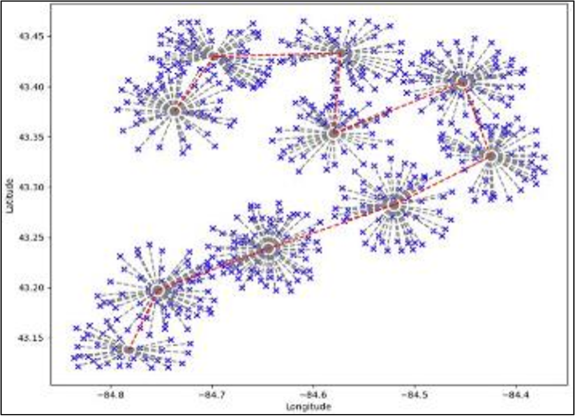
Figure 7. FLP Result without Subtours
As FLOE progresses through Phase II, the focus is on achieving greater integration with real-world data sources, such as Unmanned Aircraft System Traffic Management (UTM) feeds. The goal is to enhance situational awareness for operators managing multiple aircraft simultaneously, paving the way for scalable operations. By the end of Phase II, the system aims to transition from NASA Technology Readiness Level (TRL) 3 to TRL 6, marking its readiness for commercial deployment.
Roadmap and Future Vision
FLOE’s future development focuses on refining its capabilities and expanding its applications. In the first year of Phase II, the emphasis is on integrating real-time weather and traffic data, finalizing the system’s concept of operations, and enhancing the feedback mechanisms. The second year will see the completion of situational awareness and anomaly detection modules alongside the development of a user-friendly interface.
Beyond Phase II, the vision for FLOE includes expanding its scalability to accommodate fleets of hundreds of drones, each dynamically scheduled to meet diverse mission objectives. This scalability will be particularly valuable in emerging markets such as rural cargo delivery and advanced air mobility.
Conclusion
AI and ML techniques are the driving force behind the innovations in UA-FFOpt and FLOE. From optimizing routes and predicting environmental conditions to improving decision-making through feedback and anomaly detection, these technologies empower the system to deliver unparalleled efficiency and adaptability. UA-FFOpt and FLOE represent significant advancements in the optimization of uncrewed aircraft operations. By combining sophisticated algorithms, real-time data integration, and high-fidelity simulations, these systems offer a transformative approach to aerial mission planning.
As FLOE advances toward commercialization, its potential to enhance efficiency and adaptability across industries is unmatched. This technology not only addresses the current challenges of fleet and flight operations but also lays the groundwork for the future of uncrewed aviation. As the project advances, the incorporation of more sophisticated AI/ML methodologies will ensure its relevance and impact across industries.